Holding back the East River
A design to protect FiDi and Lower Manhattan from rising waters
Written by Michael Santora, Principal, SB+C Architecture, D.P.C. | Imagery courtesy of SB+C Architecture, D.P.C.
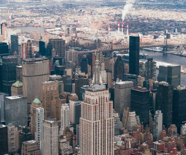
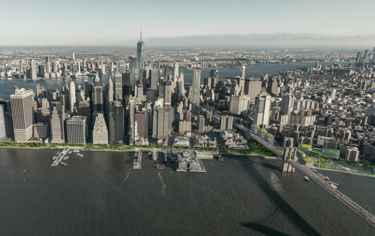
Imagine you’re standing at the eastern foot of John Street in Manhattan’s Seaport neighborhood. To the west you see the bustling Financial District, more than just the world’s economic heart, now home to more than 60,000 New Yorkers and counting, amidst a burgeoning restaurant and nightlife scene. To the north one of our most beloved landmarks, the Brooklyn Bridge, obstructed by the eyesore that is the tangled web of access ramps from the FDR Drive, and in the backdrop, Two Bridges, a neighborhood of low rise, low income housing on the brink of a massive redevelopment masterplan that will bring skyscrapers and hopefully, a rapid influx of new residents to fill them. To the south is the City’s busiest heliport and ferry terminals which reveal the vulnerability of the low-lying land that rings The Battery. To the east is impending danger, an ever-rising East River, the primary source of the destruction that left Lower Manhattan crippled for weeks after Hurricane Sandy. And beneath you, a sad excuse for a waterfront park, desperately needed to provide open space for the growing population but underused due to its undesirability. Above you the viaduct, the FDR Drive, an elevated highway in disrepair, no longer conforming to today’s highway safety standards, designed for a time when travel by motor vehicle was a luxury, where a leisurely Sunday drive was an experience in itself, a time when one could appreciate the views of Brooklyn, not the bumper in front of you.
The conundrum which is simplified as ‘the need to raise the coastal elevation to at least exceed the projected 6 foot rise of sea levels expected by the end of the century or ideally high enough to halt a potential 16 foot storm surge’ has been met with equally simple-minded solutions such as burying our concrete jungle behind a concrete wall like some medieval defense system. This may solve part of the problem, albeit with no regard to the blight it will add to an already substandard waterfront promenade, but it is far from the holistic solution New Yorkers need.
While the controversial East River Coastal Resiliency plan from Montgomery Street to East 25th Street as well as the southern section of Battery Park City is seemingly making progress, it draws further attention to the fact that the most vulnerable section of waterfront lies between the two, and is swiftly being identified as the part of the challenge no one has the solution for. A fate that is probably for the best, since the proposals still in consideration, such as a $10 billion landfill, would permanently destroy the historic character of one of the city’s most interesting neighborhoods, South Street Seaport.
Fortunately, there is light at the end of the tunnel, (pun intended) and it starts with tunneling the FDR Drive. Enter the Financial District Coastal Improvement Program (FDCIP); a multifaceted waterfront improvement initiative that is facilitated by moving the elevated section of the FDR Drive underground. These improvements have the potential to create a vibrant, accessible, open waterfront and increase real estate value from Battery Park to Corlears Hook while solving the impending environmental threats.
Having reviewed the program, Richard McCarthy, a Principal at SB+C Architecture, D.P.C., comments, “Climate resiliency in Lower Manhattan requires comprehensive and proactive solutions. FDCIP offers a holistic approach to change and carefully crafts a brighter future for residents, visitors, and workers alike.”
Rising sea levels mean more to lower Manhattan than just the threat of water rushing over the coastline in slow fashion due to climate change or in an unfathomable blast as a result of a storm. It also has a lot to do with rainwater. Inside buildings, storm pipes that carry rainwater off roofs and their surrounding property and sewer pipes that carry wastewater from the drains of our sinks and toilets are separate; however, when they leave the building, they are combined until they reach a water treatment facility. An antiquated system, nearly impossible to overhaul or separate, moves by gravity under congested streets entangled in other utilities at near capacity. And all too often a heavy rain exceeds the system’s capacity, causing the contents to be pushed through overflow gates into surrounding waterways. There are two issues with this, the obvious one about dumping raw sewage into the East River and the non-obvious one that when the sea levels rise above the overflow gates, those gates will no longer function, causing water, and all of its contents, to backflow into the street.
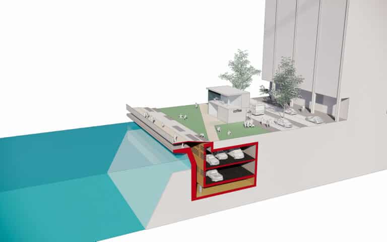
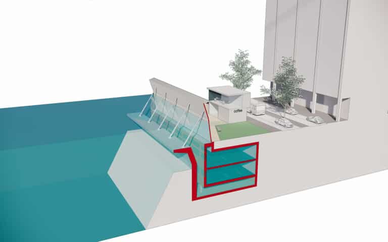
This paradox prompted the FDCIP to incorporate its solution into the program. As a result, the tunnel is intended to operate in three modes: typical day-to-day, heavy rains, and storm surges. Daily functions allow traffic to flow two ways, with an unused void beneath the tunnel which can function as an express route for the highway for emergency vehicle access, with limited access for public transit. During heavy rains, the tunnel will dually function as an overflow water detention tank as well as for regular traffic. Both of these scenarios permit the full function of the promenade located at grade above it. During a storm surge, the tunnel will be closed to traffic and act as a detention tank for sea water. The promenade will be closed to pedestrians and raise from a horizontal to vertical position, creating a temporary sea wall deflecting water into the tunnel and back to the river. When the storm subsides, the tunnel will be pumped out and cleaned, the promenade will lower, become accessible again and day-to-day operations will resume.
The benefits extend far beyond being a viable resolution to two vital water related threats. In addition, the scar bifurcating the seaport and leaving the waterfront in perpetual darkness will no longer be seen by park goers, the waterfront will be free for a deserving restoration comparable to the success of the Big Dig in Boston or the removal of the West Side Elevated Highway and Hudson River Greenway. Land once occupied by access ramps will be available for new development and property values of the existing neighbors will soar. Last but not least, the interchange between the FDR and the Brooklyn Bridge, the catalyst for congestion issues throughout Manhattan and Brooklyn could get a full redesign, based on its current and future functional needs.
“This visionary proposal responds to the most pressing issues that face Lower Manhattan with one clean move, explains Laura Argentieri, Senior Urban Designer at SB+C Architecture, D.P.C. Further elaborating, “lowering the FDR into a tunnel not only resolves issues of rising sea levels, it creatively responds to pollution and traffic that bear down on residents of Lower Manhattan, all while providing a wonderfully improved waterfront for everyone to enjoy.”
SB+C Architecture, D.P.C. are the US operating arm of Scott Brownrigg, a global top 100 architectural and interior design practice, ranked within the UK top 10.
SB+C Architecture, D.P.C. is registered with the state of New York and performs all professional services that occur in New York and throughout the United States of America where we have reciprocal licenses.